Walking in the Austrian Alps: the Dachstein Circuit

Dachstein is a splendid massif in the Northern Limestone Alps with a range of striking jagged peaks many over 2500 metres high. The Dachstein circuit is a well way-marked trek, often done over eight walking days, that embraces the diversity of the area. There is classic high mountain walking – often over 2000 metres – as well as many wooded areas, meadows and pastures, valleys and riverside routes.

The circuit is graded ‘moderate to strenuous’; there are plenty of long ascents and descents mainly following clear zigzagging paths, with a small amount of scrambling and occasional passages over snow and scree. The main challenge comes with weather. After and during rain it can be treacherous underfoot continually watching out for slippery mud,stones and ubiquitous tree roots. Distance in kilometres is not much of a guide as so much depends on the terrain but signs provide an estimate of time to reach destinations. The stages we did were all doable (rough times provided on day by day guide below) usually leaving about nine in the morning and arriving between four and five in the afternoon. By the way I won’t see my 70th birthday again so you’ll need to adjust for age.

Paths are well signed giving both the path number (as shown on map) and estimated time to reach key destinations.

The mountain huts are superbly situated and well equipped. This is Hofpurghutte (1705 metres)
Chris and I did the circuit in early July starting from Gosau (flight to Salzburg and then train to Steeg-Gosau, changing at Attnang-Puchheim, then bus to Gosau). I’ve done a day by day account below to give my impression of each day and some of the highlights as well as to illustrate the variations brought about mainly by the weather. It’s not a guide- you need the map (Kompass 1:50,000 walking map of Dachstein, Ausseerland, Bad Goisern and Halstatt). There is also a guidebook Dachstein Rundwanderweg by Reinhard Lamm (there’s an English version). These were provided by MAC Adventure as part of the package along with instructions for finding our booked accommodation.

Chris, good friend and walking companion
Gosausee to Hofpurghutte: first day’s walking and weather not promising with low clouds and threat of rain. Cable car from Gosausee to Gablonzer Hutte:

Low clouds above the cable car station at the start of walk
Getting off the cable car, it was no longer raining and visibility wasn’t too bad. Followed path 618 up a short steepish climb and then through woodland. Recent rain made the path slippery with mud, stones and tree roots. After a couple of hours the route becomes more open meadowlands with views up to the limestone peaks and down; there is a cafe bar at Stuhalm. The walk then skirts the mountain side, descending and ascending on the way with one sharp zigzag climb, helped by wire side rail. Path then becomes easier with great mountain views, we also spotted marmottes playing before reaching superbly located hut. Walk had taken about five hours including breaks. Hofpurghutte is a big and busy hut with cafeteria style restaurant- a decent plate of spaghetti bolognese at €8.50. Hosts like a bit of banter about England’s World Cup chances. No WiFi but able to follow most of England v Sweden via others’ phones and text messages.
Hofpurghutte to Ramsau: a good start to what should have been an epic day but we retreated early down to Ramsau as the weather deteriorated. Started well following signs to Dachstein Sudwandhutte; the plan was to follow the circuit to there and then descend to Ramsau for the night. It was enjoyable alpine walking- high up, pine woods but quite open and the path reasonably dry leading to stiff zigzag ascent of Sulzenhals. The summit has excellent views in all directions although clear signs of the weather changing. Carrying on we were met by a group of German walkers retreating from a lengthy passage of scree saying the wind and rain made it too dangerous. We joined them descending to Bachalm and then mountain taxi and bus to Ramsau. Only half a day’s walking and perhaps we’d been too risk averse?

View from summit of Sulzenhals (1990 metres). Rain clouds gathering
Ramsau to Guttenberghaus: Still low clouds higher up and the hotel manager told us the cable car (Gondola) up to the Dachstein Sudwandhutte was not running because of the weather. We later heard that this wasn’t the case and we’d uneccessarily missed a key part of the circuit, across the glacier. The alternative was a walk along the valley and then a 1000 metre ascent. The climb was steady, for me tiring, and the weather improved greatly. 4-5 hours of walking but I did take it pretty easily!
 Again the refuge was superbly located, a wooden building that was originally built 104 years ago although substantially extended and refurbished in the meantime. A very congenial host, good range of food and drink, and lots of historical photos and artefacts displayed around the hut all helped create a special atmosphere. At 2164 metres it got pretty cool though when the sun went down.

Guttenberghaus

Looking back at Guttenberghaus after a short ascent
Stoderzinken to Knoppen
In the morning there was rain and low cloud but the route mainly descended so we stuck to it.

The outlook from Stoderzinken before starting the day’s walk

The path through the Notgasse ravine
Continuing we stopped at the isolated village of Viebergalm and were able to appreciate a warm room and a bowl of clear soup with a substantial cheese dumpling!

Kasspressknoedel: alpine cheese dumpling served in beef broth
Knoppen to Hallstatt:
This was the longest distance of the day’s – just over 16 miles but mainly on the level with a good walking surface. There is an option to take a bus to Bad Aussee and walk from there but we decided to walk it all; it was forecast to be a sunny day and there was plenty of interest on the way and it wasn’t too strenuous. We doubled back for 30 minutes to rejoin the trail and then along to Odensee an attractive lake set in woods and popular for fishing, swimming and boating. Then on to Bad Aussee to continue the trail along the river Traun.

The river Traun
It’s a longish stretch to Obertraun where we were to catch the ferry to Hallstatt but good walking- few ups and downs, decent surface, mainly shaded and alongside the river with the mountains in the near distance. There is a cafe restaurant en route. The walk ends skirting Obertraun and ends at Hallstattsee ferry stop. Seven hours walking and in good time for the last ferry at 16.40. It’s a twenty minute trip across to Hallstatt with great views across the lake both back to Obertraun and coming into Hallstatt.

Looking back at Obertraun from the ferry
Hallstatt: we decided on a rest day here when planning the trip and were glad we did. Admittedly Hallstatt is a massive tourist hot spot packed during the day so it’s a bit of a change from the mountain stages. It’s particularly popular with Chinese visitors.; in fact there’s a replica Hallstatt built in the Guangdong province of China. What’s its appeal? It was one of the first human settlements and has a long and rich history stretching back to the Bronze Age (a large Bronze Age burial site was discovered in the 19th century). The mining of salt formed the basis of Hallstatt’s economic importance as a trading centre. By taking the furnicular or path (300 metres+ of ascent) it’s possible to visit the burial site and the salt mine as well as get great views down to Hallstatt.

Hallstatt seen from viewing point near the salt mine

Hallstatt- perched between mountain and lake with many attractive 16 and 17 century buildings
The trail proceeds along the Brine-pipeline; this was first put in operation in 1607 to take the brine from the mine to a salt factory in Ebensee and a gently descending trail accompanies it. Unfortunately the trail is closed for summer and autumn of 2018 following storm damage so a key part of the walk was missed. Instead we took the train to Bad Goisern and picked up the trail there. As compensation we did witness part of the start of the Salzkammergut mountain bike trophy that is known as Europe’s toughest mountain bike race: five thousand competitors competing over a number of different distances. The ‘adrenaline junkies’ can do a race of 210km with 7119 metres altitude difference.

Some of the competitors at the start of the 53km version of Salzkammergut challenge
The walk up to Goiserer Hutte (1000 metres of ascent) took me about three hours- a steady climb starting with road and forest track and then stoney path with fine views down to Bad Goisern and the valley. The hut was originally built in 1932/3 and had recently been refurbished and was very well maintained and served first class food.

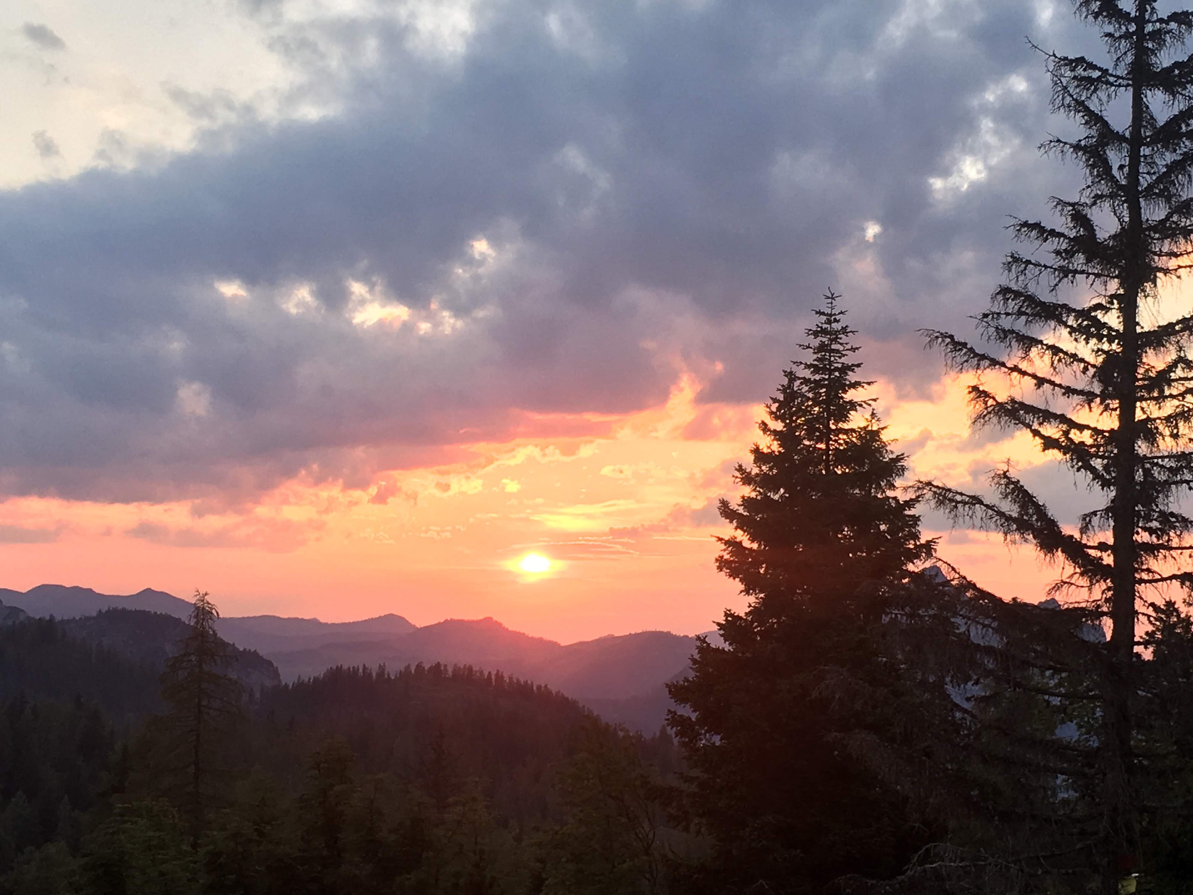
Sunset view from Goiserer Hutte
Goiserer Hutte to Gosau
The hut is superbly located with great views but to get a 360 degree view including across to the high Dachstein, the thing is to ascend the summit of nearby Hoch Kamberg (1833 metres) that takes about 45 minutes. We did this in the early morning and it was well worth it with great views in all directions in the early morning light.

Early morning view from Hoch Kamberg
Back to the hut for breakfast including a local blue sheep milk’s cheese and proper salami, not luncheon meat plus limitless supply of coffee and then off on the last stretch- the descent to Gosau.
This began through an open wooded pastoral area and gradually became more densely wooded before following a road into Gosau, where it started to rain. About three and a half hours walk and the circuit was completed and all that was left was to watch the World Cup final.

Back in Gosau at the end of the walk
